What to Expect
Baxter is unlike any other state park in the country, and not just because of the scale. Former Maine Governor Percival Baxter spent more than three decades purchasing land from timber companies with his own money and donating each parcel to the state, with a single condition: the land would remain forever wild. The Baxter State Park Authority manages it entirely separately from the Maine state park system, which means the rules are stricter and the wilderness standard is real. You will not find a gift shop, a cell signal, a gas pump, or a food concession inside the gates. The park roads are unpaved, narrow, and posted at 20 mph. If you break down in the interior, you are a long walk from help.
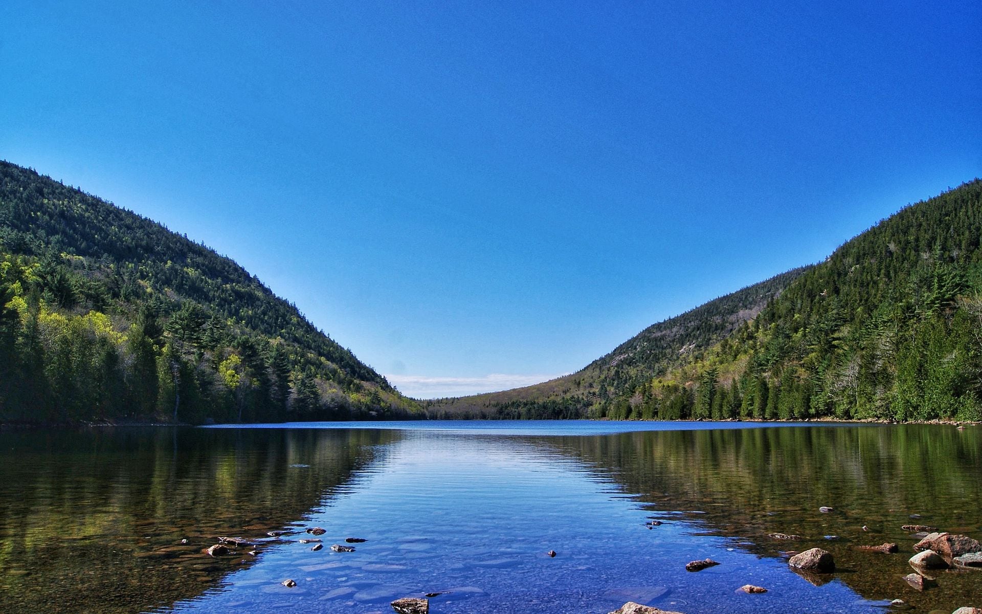
The result is a park that still looks and feels like the North Woods as it existed a century ago. Moose cross the gravel roads at dusk. Loons call across Daicey Pond. The summit of Katahdin is above tree line, bare granite swept by wind, with views reaching into Quebec on clear days. Hikers finishing the 2,190-mile Appalachian Trail sign the register at Baxter Peak and cry. It is the kind of place that earns its reputation through difficulty and distance rather than through ease of access. Part of The Maine Highlands, Baxter sits at the far northern end of the region, roughly 90 miles from Bangor and 175 miles from Portland.
What to Do There
Hiking is what most people come for, and hiking in Maine does not get more serious than Katahdin. The Hunt Trail, which is the northern terminus of the AT, covers 10.4 miles roundtrip from Katahdin Stream Campground with about 4,200 feet of elevation gain. The Cathedral Trail from Roaring Brook Campground is steeper and shorter, gaining most of that elevation in under two miles of rock scrambling. Both routes converge near the summit. The Knife Edge, a one-mile traverse connecting Baxter Peak to Pamola Peak, is the route that people either seek out or immediately decide is not for them. The ridge is one to three feet wide in places, with thousand-foot drops on both sides. It requires steady nerves and dry weather. If there is any doubt, skip it and come down the way you went up.
Not every hike here ends at the summit. South Turner Mountain, reached by a 3.2-mile roundtrip trail from Roaring Brook, sits directly across from Katahdin and gives you one of the best views of the mountain without requiring technical moves. Sandy Stream Pond, about 1.5 miles from Roaring Brook Campground, is a reliable moose-viewing spot at dawn and dusk from mid-June through September. Moose wade in to feed on aquatic vegetation, and the pond reflects Katahdin on calm mornings. Chimney Pond, a glacial tarn cradled below Katahdin's north face, is worth a full day on its own even if you do not push for the summit: the 3.3-mile trail from Roaring Brook to the pond climbs through old spruce-fir forest and opens onto a dramatic cirque that holds snow into June most years. For a quieter day, Daicey Pond and Kidney Pond offer canoe rentals (estimated $20–30 per session) and flat-water paddling with mountain views and essentially no crowds.
AT thru-hikers finishing their northbound journey arrive at Baxter Peak from late July through October, and seeing one reach the summit register after six months on the trail is its own kind of spectacle. If you are a day hiker planning to share the mountain with thru-hikers in August, expect emotional reunions and a fairly crowded summit. September pulls noticeably fewer day hikers and the foliage on the approaches turns quickly in the highlands. The best state parks in Maine offer different experiences, but none of them ask as much of you as Baxter does.
Getting There and Access
Bangor International Airport (BGR) is the most practical entry point, roughly 90 miles from the Togue Pond Gate via I-95 North to Exit 244 at Medway, then Route 11 South into Millinocket (about 18 miles), and another 18 miles out the Millinocket Lake Road to the gate. The drive from Bangor runs about two hours under normal conditions. From Portland International Jetport (PWM), plan on 3.5 hours for roughly 175 miles using the same I-95 route through Augusta and on to Medway. A car is not optional here; there is no shuttle, no bus, and no alternative once you leave Millinocket. If you are starting from Portland, Becky's Diner on Commercial Street is a reasonable early-morning fuel stop before you hit I-95 North; it opens at 4 a.m. and keeps hikers well fed before a long drive. Further north, if you are making the drive through Augusta, The Red Barn on Riverside Drive is a well-regarded seafood shack with lobster rolls and fried clams at reasonable prices, right off I-95 before you continue north.
Two gates access the park. The Togue Pond Gate on the south side (the main entrance for most Katahdin-bound hikers) opens at 6 a.m. and closes at 10 p.m. The Matagamon Gate on the north side, reached via Route 159 from Patten, serves the park's northern interior. Gate roads inside are gravel and unpaved; the eight miles from Togue Pond to Roaring Brook Campground take 20–30 minutes. Day-use vehicle fees run approximately $35 for non-residents and $15 for Maine residents. Parking reservations for the Katahdin trailheads (Roaring Brook and Chimney Pond in particular) are required from mid-May through mid-October and are released in January at BaxterStatePark.com. Prime summer weekends fill within hours of release. Cell service vanishes near the Millinocket town line and is gone entirely inside the park, so download your maps, permits, and trail information before you leave town.
Best Time to Go
The Katahdin trailheads open in mid-May, but the upper mountain often holds ice and snow well into June, and the Knife Edge can be genuinely dangerous in those conditions. July and August are peak season: warm days, long daylight, and the busiest trailhead parking lots. These are also the months when parking reservations fill fastest, so book in January if a summer date is the goal. September is worth considering seriously. The crowds thin after Labor Day, the moose are more visible along the pond edges, and the highland foliage begins turning in late September, with blueberry fields near the summit going red and the birch and maple below following by early October. You will have a better chance of a clear summit day in September than in July, when afternoon thunderstorms are common.
October brings the risk of early snow above 3,000 feet, and the park typically closes the Katahdin trailheads in mid-October once conditions become hazardous. The interior campgrounds close in October as well. Winter access for snowshoeing and cross-country skiing exists on a limited basis, but the gate road is not maintained for winter travel and requires a permit from the park authority. Spring (May and early June) means mud, black flies, and unpredictable snow on the upper slopes. Most first-time visitors are better served by waiting until late June at the earliest, when the trails have dried and the flies have eased. For a comparison of how the broader region fits into a Maine trip, Moosehead Lake is about 70 miles west of Millinocket via a combination of Route 11 and Route 15, roughly 90 minutes of driving on two-lane roads, and makes a logical second stop in the Highlands.
Good to Know
Dogs are not allowed on any trails in Baxter State Park. This is one of the rules that surprises people most, and there are no exceptions. Leashed dogs are permitted in campgrounds and on the access roads, but the moment you hit a trail, they are not welcome. If you are traveling with a dog, plan accordingly before you drive two hours from Bangor. Fires are allowed in designated fire rings at campgrounds only; no backcountry fires. Bear canisters are required for overnight trips into the backcountry and are available for rent at park campgrounds (estimated $5–10 per trip). Overnight camping requires a reservation through BaxterStatePark.com, and campground reservations open in early January alongside the day-use parking slots. The most popular sites (Chimney Pond and Roaring Brook) book within the first day or two.
Stock up on food, fuel, and supplies in Millinocket before you enter the park. The town has a grocery store, a gas station, and a handful of restaurants and outfitter-style shops catering to hikers and paddlers heading into the North Woods. There are no ATMs inside the park. The Baxter State Park Authority phone is (207) 723-5140 if you need to confirm conditions or reservations before arrival. A one-page trip plan left with someone outside the park is worth doing for any overnight, and strongly recommended for solo Katahdin summits. For a broader look at how Baxter fits into a longer Maine trip focused on the outdoors, the Maine Highlands region page covers Moosehead Lake, the Allagash, and other North Woods destinations alongside Baxter.
Frequently asked questions
Do you need reservations to visit Baxter State Park?
Yes, if you plan to park at any of the Katahdin trailheads (Roaring Brook, Chimney Pond, Katahdin Stream, or Abol) during the main season from mid-May through mid-October. Day-use parking reservations are required and are released in January at BaxterStatePark.com. Peak summer weekends and holidays fill within hours of the January release date. If you are visiting in late September or early October on a weekday, you may find spots available closer to your visit, but the July and August Saturdays book out essentially instantly. Overnight camping reservations are separate and open on the same January schedule. There is no reservation required simply to drive through the park or visit Daicey Pond and Kidney Pond on the western side, where parking is typically less constrained.
How hard is the hike up Mount Katahdin?
Katahdin is a serious mountain and should not be underestimated. The most common route, the Hunt Trail from Katahdin Stream Campground, covers 10.4 miles roundtrip with roughly 4,200 feet of elevation gain. Most fit hikers with no prior Katahdin experience allow 8 to 10 hours roundtrip. The trail starts in forest, transitions to steep rock scrambling on Hunt Spur above treeline, and finishes on a broad open plateau leading to the summit at 5,267 feet. The Knife Edge traverse between Baxter Peak and Pamola Peak adds significant difficulty and exposure; it is a one-mile ridgeline one to three feet wide in places with steep drops on both sides. The park recommends hikers be comfortable with significant exposure and technical rock before attempting the Knife Edge. Weather on the summit changes fast. Afternoon thunderstorms are common in July and August, and the park requests that hikers be off the summit by 1 or 2 p.m. to avoid lightning exposure.
What town do you stay in near Baxter State Park?
Millinocket is the main gateway town, roughly 18 miles south of the Togue Pond Gate via the Millinocket Lake Road. It has motels, a few small inns and rental cabins, a grocery store, gas stations, and restaurants. Prices are moderate (estimated $80–150/night for most lodging), and the town is well set up for hikers, paddlers, and people heading into the North Woods. Patten, a smaller town near the Matagamon Gate on the north side of the park, is an option for those exploring the northern interior. There is also lodging inside the park itself, in the form of park-operated cabins at Daicey Pond and Kidney Pond and lean-tos and tent sites at the campgrounds, all booked through the BaxterStatePark.com reservation system. Inside-the-park lodging is rustic (pit toilets, no electricity, no running water at most sites) and fills very quickly.
Can you see moose at Baxter State Park?
Yes, Baxter is one of the most reliable places in Maine to see moose. Sandy Stream Pond, about 1.5 miles from Roaring Brook Campground on a flat trail, is the park's best-known moose-viewing spot. Moose wade into the pond to feed on aquatic vegetation, especially in the early morning and around dusk. Late June through September is the most productive window. The park's perimeter roads and interior roads also produce moose sightings at dawn and dusk year-round, and the Daicey Pond and Kidney Pond areas on the western side of the park are reliably good. Drive slowly on the gate roads at low light and watch the shoulders; moose appear suddenly. For a broader look at North Woods wildlife viewing, the hiking in Maine page covers trail access across the state's wilderness areas.