How We Picked These Hikes
Acadia has good trails in every corner of the park, so the question is what kind of good you want. We picked seven routes that together span the range: a tidal pond walk that ends at the park's best lunch stop, a short family summit with fjord views, a cliff scramble using iron rungs and ladders, a long open ridge to the highest point on the US East Coast north of Florida, a technical ledge climb that closes seasonally for falcon nesting, a coastal headland loop with direct Atlantic exposure, and a moderate route on the quieter western side of Mount Desert Island. Together they represent what the park offers rather than a list of every named peak. For a broader look at what Maine has beyond the park, start at the Maine Travel Guide.
A few logistics to know before you go. The park entrance pass runs about $35 per vehicle or $80 for an America the Beautiful annual pass, valid at all federal recreation sites. If you want to drive to the Cadillac Mountain summit via the Summit Road, that requires a separate timed vehicle reservation through recreation.gov, released in two windows: 90 days ahead and again two days ahead of your visit. Hikers who walk up the North Ridge or South Ridge trails do not need that reservation. Summer parking at Sand Beach and Jordan Pond fills before 8am on weekends in July and August. The free Island Explorer shuttle serves most major trailheads from late June through mid-October and is a more reliable option than trying to time a parking spot.
Cadillac Mountain North Ridge Trail
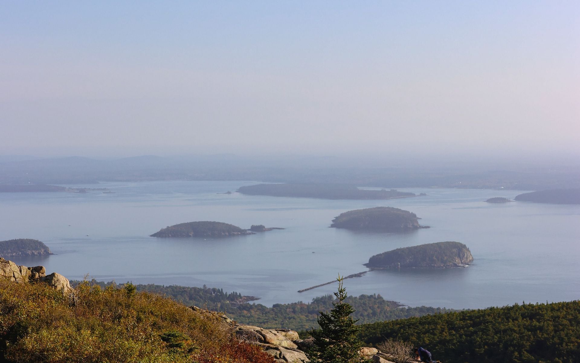
Cadillac Mountain, at 1,530 feet, is the highest point on the US East Coast north of Florida and the first place in the country to see the sunrise from mid-October through early March. The North Ridge Trail is the most direct route to the summit, 4.4 miles roundtrip with roughly 1,000 feet of elevation gain across open pink granite ledges. The trailhead sits at the Cadillac North Ridge parking area off Eagle Lake Road, and the trail stays above the treeline for most of its length, so views open within the first quarter mile and hold all the way to the top.
The summit has a paved loop, a gift shop, and restrooms. It is crowded in peak summer, especially after the Summit Road opens up. For the best experience, walk up via the North Ridge rather than driving, and time it for early morning or late afternoon when the light is low and the Summit Road crowd is thinner. From the top on a clear day you can see the Porcupine Islands, Frenchman Bay, and the open Gulf of Maine to the east. The Porcupine Islands and Mount Desert Island's own island character are part of what makes this coastline worth exploring separately: the best islands in Maine guide covers the offshore options beyond the park.
Jordan Pond Shore Path
The Jordan Pond Shore Path is a 3.3-mile loop around one of the most transparent glacially carved ponds in the northeast, with the two rounded hills called the Bubbles reflected at the north end. The trail is almost entirely flat, a mix of packed gravel and rooty sections close to the water, and it is the right call for families with young children or anyone who wants a full nature walk without significant climbing. The Bubbles themselves are short side hikes off the north end of the loop, each about 0.4 miles up with a few hundred feet of gain.
The Jordan Pond House sits at the south end and has been serving afternoon tea and popovers since the late 1800s. The popovers are a genuine tradition, not a tourist gimmick: the recipe goes back over a century and the terrace seating over the pond makes for a good reason to plan your timing around lunch. Arrive before 11am to avoid lines in July and August. The Island Explorer shuttle stops at Jordan Pond from late June through mid-October, which is the practical way to get here without fighting for one of the limited parking spots.
The Beehive
The Beehive is a 1.6-mile loop that climbs about 450 feet up the open cliff face of a small coastal summit using iron rungs and wooden ladders fixed directly into the granite. The exposure is real: you are on an open face with drop-offs, and it is not suitable for anyone with a fear of heights or for dogs. But it is one of the most satisfying short hikes in the park, and the views from the top over Sand Beach and the open Atlantic are immediate and direct. On a clear morning you can see the Schoodic Peninsula across Frenchman Bay.
The trail starts at the Bowl trailhead, which shares a parking area with Sand Beach on Park Loop Road. That lot fills before 8am on summer weekends, so the Island Explorer is the reliable option. One detail most visitors miss: the Beehive faces east, which means the iron rungs are in shade and often wet or cold in the morning in spring and fall. A dry, late-morning start is better than an early one when moisture is on the rock. Descend via the Bowl trail rather than reversing the rung sections, which are harder going down.
Precipice Trail
Precipice is Acadia's most technically demanding maintained trail, a 3.2-mile roundtrip up the east face of Champlain Mountain via an extensive system of iron rungs and ladders across open exposed ledges. It gains about 1,000 feet in under a mile. The significant catch: the trail closes from mid-April through late August most years for peregrine falcon nesting on the cliff face. That makes it unavailable during the busiest stretch of summer. Check the NPS Acadia website for exact closure dates before you plan, because the window shifts year to year depending on nesting progress.
When the trail is open (late August through mid-April, and sometimes earlier in late summer if nesting is complete), it is worth going out of your way for. The summit of Champlain Mountain looks east over the open ocean and west over the full breadth of Mount Desert Island, with the Porcupine Islands and Frenchman Bay laid out below. The trailhead parking area is on Park Loop Road, about 1.5 miles north of the Sieur de Monts spring entrance. A fall visit in September or early October pairs the trail with peak foliage on the lower slopes and gives you better odds on the closure being lifted.
Acadia Mountain Trail
Acadia Mountain sits on the western side of Mount Desert Island, above Somes Sound, which is the only true fjord on the eastern seaboard of the United States. The hike is 2.5 miles roundtrip with about 500 feet of elevation gain through spruce and oak forest before opening onto summit ledges with views across the sound to the main island ridgeline. It is one of the better hikes in the park if you are staying on the western side of the island, and it draws a fraction of the traffic that the eastern trailheads see.
Start from the Acadia Mountain trailhead on Route 102, about 3 miles south of Somesville. The parking area is small, so early morning is the practical move in July and August. The full loop descends the south face and includes a short spur to the sound's shore at Valley Cove before returning to Route 102. That cove section can be muddy after rain; waterproof boots are worth it. The drive from Bar Harbor takes about 25 minutes, and the quiet of the western side of the island feels like a different park from the Park Loop Road.
Great Head Trail
Great Head is a 1.6-mile loop on the granite headland east of Sand Beach, with views out over the open Atlantic and back across the curve of the beach. It is the shortest loop in the park that gets you onto actual exposed coastal headland, with surf breaking below the cliff edge on the ocean side. The terrain is rocky and rooted but manageable for most hikers, and the sense of space at the eastern point of the headland is one of the better payoffs for the effort involved.
Access starts at the east end of Sand Beach via a short beach crossing, or from the Sand Beach parking area on Park Loop Road. The loop works best in a counterclockwise direction so the ocean view opens as you climb rather than after you have already crossed the point. Combined with an hour at Sand Beach, Great Head makes a full morning without driving anywhere else. Fog can reduce the ocean views to near zero on summer mornings; afternoon visits tend to clear.
Flying Mountain
At 284 feet, Flying Mountain is the lowest named summit in the park. The hike is 1.5 miles roundtrip with about 150 feet of gain, but the views from the top down into Valley Cove and across Somes Sound are out of proportion to the effort. It is the right call for families with children under 8 who want a real summit without the rung sections, for late afternoon when energy is low, or as a first-day warmup before attempting something more demanding.
The trailhead is at the Fernald Point Road parking area, off Route 102A on the southwestern side of the island near Southwest Harbor. The descent continues into Valley Cove and loops back through the forest, making a complete circuit without retracing steps. Southwest Harbor is about a 30-minute drive from Bar Harbor and serves as a quieter base for the western side of the park. If that is where you are sleeping, Flying Mountain is the most accessible summit from that end of the island.
How These Hikes Compare
| Trail | Distance | Elev. Gain | Difficulty | Best For |
|---|---|---|---|---|
| Cadillac North Ridge | 4.4 mi RT | 1,000 ft | Moderate | Summit views, sunrise |
| Jordan Pond Shore Path | 3.3 mi loop | Minimal | Easy | Families, all abilities |
| The Beehive | 1.6 mi loop | 450 ft | Strenuous, iron rungs | Short scramble, ocean views |
| Precipice Trail | 3.2 mi RT | 1,000 ft | Very strenuous | Technical climb, late season |
| Acadia Mountain | 2.5 mi RT | 500 ft | Moderate | Quiet side, fjord views |
| Great Head | 1.6 mi loop | Moderate | Easy-moderate | Coastal headland, quick loop |
| Flying Mountain | 1.5 mi loop | 150 ft | Easy | Young kids, western side |
For a first visit, Jordan Pond plus the Beehive covers easy to serious in a single day. If you have two or three days, add Cadillac North Ridge and Acadia Mountain for a thorough look at what the park offers on both sides of the island. Bar Harbor is the practical base for the eastern trailheads. The best small towns in Maine include Bar Harbor for good reason: it has lodging and restaurants within walking distance of the Village Green, and the eastern park entrances are 5 to 10 minutes by car. The Bar Harbor Inn & Spa on Newport Drive and the Harborside Hotel, Spa and Marina on West Street both put you in the center of town. Atlantic Oceanside Hotel on Eden Street sits right on the park boundary along ME-3, making it a short drive to both the Hull Cove entrance and the Cadillac North Ridge trailhead. For the quieter western-side hikes, Southwest Harbor has smaller inns and fewer summer crowds. To book lodging across the region, the Hotels and Inns directory covers options from Bar Harbor to Southwest Harbor.
Frequently asked questions
Do you need a reservation to hike in Acadia National Park?
No reservation is required to hike. You need a park entrance pass (about $35 per vehicle, or an $80 America the Beautiful annual pass), which you can buy at the entrance gates or in advance at recreation.gov. The one exception is driving to the Cadillac Mountain summit via the Summit Road, which requires a separate timed vehicle reservation from late May through late October. Hikers who walk up the North Ridge or South Ridge trails do not need that vehicle reservation. Trailhead parking at Sand Beach and Jordan Pond does not require a reservation, but it fills very early on summer weekends.
When is the best time to hike in Acadia National Park?
September through early October is the best overall window. Crowd levels are lower than July and August, weather patterns tend toward clear and dry, and fall color on the lower slopes starts by late September. July and August have the most reliable warm weather but the worst trailhead parking congestion. Spring hiking (late April through June) is good on the open ridges once snow clears, typically by late April, but the Precipice Trail is closed from mid-April through late August for peregrine falcon nesting. The park stays open through winter; summit trails above the treeline can be icy from November through March and require microspikes.
What is the easiest hike in Acadia with a good view?
Jordan Pond Shore Path is the easiest full trail in the park with consistent scenery: flat, 3.3 miles, and the Bubbles reflected in the water the whole way. Flying Mountain (1.5 miles, 150 feet of gain) is the easiest genuine summit with views over Somes Sound and Valley Cove. For ocean exposure with minimal elevation, Great Head is 1.6 miles with moderate terrain and direct Atlantic views from the headland. None of these three involve iron rungs or significant climbing.
Can you take the shuttle to Acadia trailheads?
Yes. The free Island Explorer shuttle connects downtown Bar Harbor to Sand Beach, Jordan Pond, the Cadillac North Ridge trailhead, and other major access points from late June through mid-October. Route 4 covers most of the eastern side of the park. The shuttle runs every 20 to 30 minutes at peak times in July and August. It is the practical way to reach Sand Beach and Jordan Pond without arriving before 7am to secure a parking spot. Schedules adjust through the season; check the Island Explorer website before you go.
Are dogs allowed on Acadia hiking trails?
Dogs are allowed on most Acadia trails on a leash of 6 feet or less, but several areas are off-limits. Dogs are not permitted on the Beehive Trail, the Precipice Trail, or at Sand Beach and Echo Lake Beach. The carriage roads are fully dog-friendly and a good option for a long walk with a dog. The Jordan Pond Shore Path allows dogs. If you are planning a day with both dogs and kids, Jordan Pond and the carriage roads cover the most ground without restriction.
How far is Acadia National Park from the rest of Maine?
Bangor International Airport (BGR) is the closest major commercial airport, about 1 hour from Bar Harbor via Route 1A and Route 3. Portland International Jetport (PWM) is larger and better connected, but the drive to Acadia is about 3 hours on I-95 to Bangor and then Route 3 south to Mount Desert Island. From the Maine Beaches region along the southern coast, plan for about 4 to 4.5 hours driving north on Route 1. The coastal route on Route 1 is slower but more interesting than the highway; most visitors combine both, taking I-95 north and Route 1 back down.